|
You are not Logged in! Log in to check your messages. |
|
|
Check todays hot topics |
Web2Project Sign in
Project MOSES
Moving Sands - Equilibrium State of Crenulated Coasts (MOSES - PTDC/GEO-GEO/3981/2012)
This project is funded by PTDC programme, with 150.000 Euro for 2 years. Starting date: not set yet. Partnership: UAlg-University of Algarve, UL-University of Lisbon and CINTAL-Centro de Investigação Tecnológica do Algarve. People involved: Delminda Moura (Coordinator-UAlg) and António J. Silva (CINTAL).Abstract:
The knowledge on coastal processes and beach processes in particular is not only of basic and
practical importance, for instance in engineering applications but also of socio-economic
relevance. In a crenulated coastline with beaches and headlands, the balance between the incoming
and the lost sediment determines the beach stability that ranges between static equilibrium to unstable.
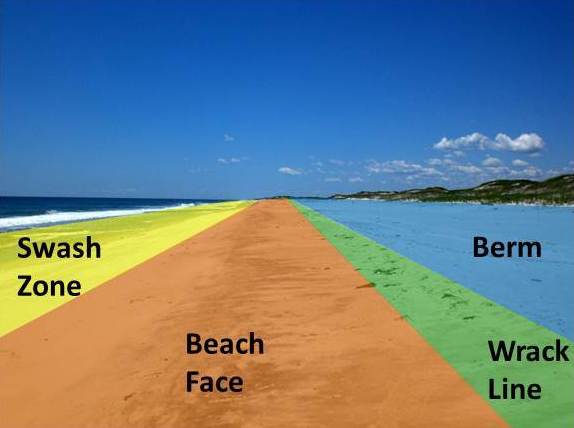
Headlands are natural barriers to the alongshore drift and therefore reduce the amount of sediments incoming to the updrift adjacent beaches. Over short time scales the beaches in a crenulated coast are modified mainly by wind waves causing setup and setdown (rising and lowering of the mean water level) in the surf zone leading to a very complex pattern of circulation modified by the interaction between the currents induced by waves and the incident waves. The mechanisms involved in morphological modifications in such environments are still not well understood. Future behaviour of beaches within a headland-beach system is of fundamental interest on coastal evolution once they represent a buffer to the waves attack into the cliff backing them and may be predictable using numerical models (e. g. UNIBEST and MEPBAY) feed by bathymetric, tidal, nearshore waves and sediment influx data. Other methods than numerical modelling such as artificial neural networks have been recently used in order to predict the headland-bay beaches being important to know as many cases as possible aiming to train the artificial neural networks.
Beach nourishment is a viable engineering alternative for shore protection and an important technique for beach restoration. Any project of beach nourishment requires the knowledge on dynamic processes and displaced sand volumes over several spatial and temporal scales. Tracers, sand traps and morphological changes are among the common methods to monitor the alongshore transport within the swash and surf zones. However, it is recognized that the methodology used to determine the sand transport in the field, as well as numerical modelling based on field observations should be improved in order to a better understanding of the complex nearshore hydrodynamic and the associated sand transport in headland-beach systems.
This project proposes an innovator and unexplored approach to trace the alongshore drift as induced by waves and currents that consists in using acoustic techniques coupled with the more traditional approach of marked sands and digital image processing to quantify the amount of sediment crossing the shore. This multi level approach will allow a mutual calibration of techniques. This research will be carried out at the centre Algarve (southern Portugal) crenulated coast where beaches are of fundamental importance to prevent cliffs against receding as well as of socio-economic importance.
Objectives:
The objective of project MOSES can be summarized as follows:
- (i) to quantify the amount of sediment crossing the shore in a headland-beach system through a multi level approach;
- (ii) to produce a tool in a Geographical Information System (GIS) environment in order to characterize the equilibrium state of the beaches in crenulated coasts according to different wave climate and sedimentary transport.
Partnership

![]() RSS Feed | Contact |
Accessibility | Products |
Disclaimer |
CSS and
XHTML
RSS Feed | Contact |
Accessibility | Products |
Disclaimer |
CSS and
XHTML
©2012 SiPLAB, Design:
OSWD